UPDATE: As of 2013 this project is no longer being update, though we've kept the map available fro download.
The UCS California Renewable Energy Projects Map is a free, publicly available, interactive tool that allows users to explore the locations of renewable energy projects qualifying for California’s Renewables Portfolio Standard Program (RPS).
The map provides information about the type of facility, its location, the year it was built, and its electricity generation capacity. The map also allows you to layer on California state assembly and senate district boundaries. All the information comes from public sources.
To use the map:
1) Download and install Google Earth on your computer (free).
2) Download the California Renewable Energy Project Map file (KMZ) to your computer.
3) Open the map file with Google Earth. Renewable energy projects will appear automatically.
The screenshot below is a sample image appearing at a large scale. As the user zooms in in on the map, facilities appear with more detail.
Users can report errors or provide additional information by sending an email to [email protected].
Related resources

State Electric Vehicle Benefits

Feet To The Fire
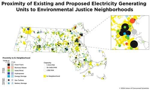
Siting for a Cleaner, More Equitable Grid in Massachusetts