Table of Contents
For years, casual observers and anti-science pundits have pointed to snowfall and cold weather to question the scientific reality of human-induced climate change. Such cherry-picked misinformation obscures the work scientists are doing to figure out just how climate change is affecting weather patterns year-round.
Is global warming really happening?
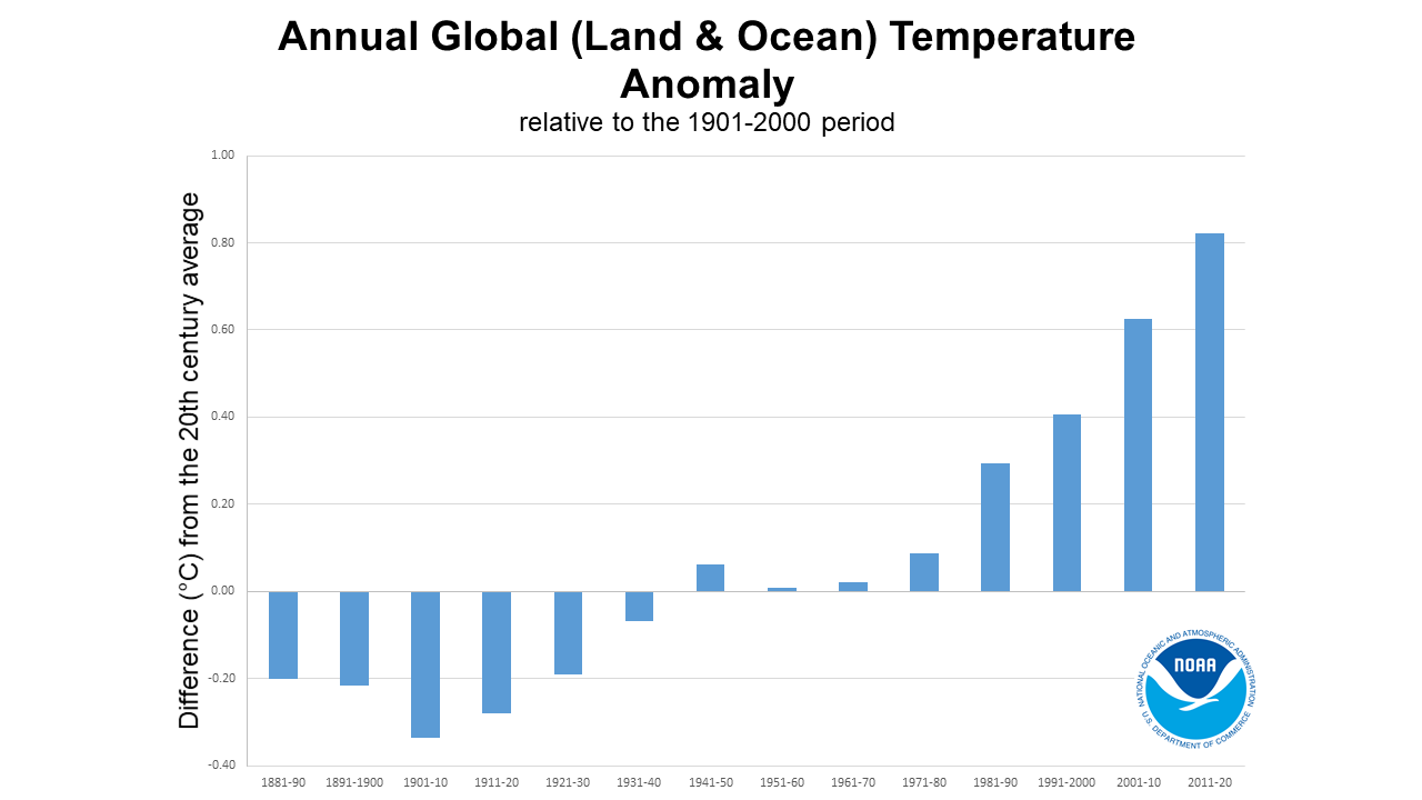
Absolutely. Global warming refers to an upward trend in global average temperatures. Federal agencies, universities, the latest climate assessments, and research centers around the world have all concluded that Earth is warming. That conclusion is based on hard data, such as temperature measurements on land and water around the world for more than a century.
Global average temperatures in 2020 were 1.76 degrees Fahrenheit (0.98 degrees Celsius) warmer than the 1901-2000 base period according to researchers at the National Oceanic and Atmospheric Administration (NOAA). The world has just finished the hottest decade on record.
What’s causing this observed warming? The primary driver is an increase of heat-trapping emissions in the atmosphere that occurs when we burn coal, oil, and gas to generate electricity, drive our cars, and fuel our businesses.
Arctic sea ice surface extent has decreased by this much per decade, about twice the area of Nevada.
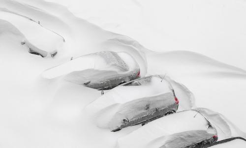
What about all this snow? Shouldn’t warmer temperatures prevent snow from forming?
Even though the planet overall is getting warmer, snow and cold weather still occur, particularly at high elevations and latitudes. But that doesn’t disprove global warming.
To understand this, it’s helpful to differentiate between weather—what’s happening outside the door right now—and climate, which is the pattern of weather measured over a period of decades.
Northern hemisphere winter weather patterns are a complex interplay between the upper atmosphere conditions over polar regions and mid-latitude conditions over the oceans and land.
Over the course of a decade, cold outbreaks can bring colder-than-normal winter conditions in lower latitudes. At the same time, warm outbreaks in higher latitudes bring warmer-than-normal temperatures—and these occur simultaneously. For example, a citrus crop in Texas might freeze while a dogsled race in Alaska is above freezing at the starting line.
Climate change carries potential implications for many of these factors, including Arctic warming, the polar jet stream, the polar vortex, and ocean conditions such as El Niño or La Niña in the Pacific Ocean. Generally, climate change makes extreme and erratic weather more likely—and in some cases, more severe.
The connection between the Arctic and more extreme weather events
Scientists are looking into the connection between changes in the Arctic polar region and more extreme weather events across the mid-latitudes. What they’re discovering may help explain some instances of extreme cold weather and snow.
In the Arctic, sea ice and glaciers are receding, and the temperature of permafrost is increasing. These trends reflect “polar amplification,” which means the temperature increases there are higher than global averages. Many conditions are unprecedented, including the record low extent of Arctic sea ice.
The Fifth Assessment Report of the Intergovernmental Panel on Climate Change (IPCC), or AR5, states that Arctic sea ice surface extent has decreased by 0.17 million to 0.2 million square miles (about twice the area of Nevada) per decade—changes considered unprecedented in at least the last 1,450 years. Summer minimum sea ice extent recorded in 2020 was the second lowest observed since 1979, when satellite observations began.
The polar vortex, jet stream, and El Niño
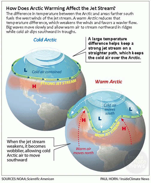
The polar vortex, or stratospheric jet stream, is a large area of low pressure and cold air surrounding both of Earth’s poles. The expansion and shifting of the polar vortex to various degrees is a regular occurrence during the winter.
In large part because of Arctic amplification, the behavior of the polar vortex has changed over recent decades. This in turn can influence the behavior of the jet stream, short for “tropospheric polar jet stream.” The jet stream is a current of fast-moving air found in the area of the atmosphere where weather occurs and jets fly. It’s formed along the boundaries between hot and cold air and becomes more pronounced during winter, when the Arctic and mid-latitude air masses more strongly contrast with each other.
An elongated polar vortex can lead to a wavier jet stream with higher latitude peaks and lower latitude troughs. When a deep trough occurs over a northern hemisphere land area, this brings cold Arctic air to lower latitudes and unusual weather for those areas as a general rule. At the same time, the higher peaks bring warmer air from lower latitudes to higher latitudes, leading to unusual weather in Alaska, northern Canada, or northern Eurasia.
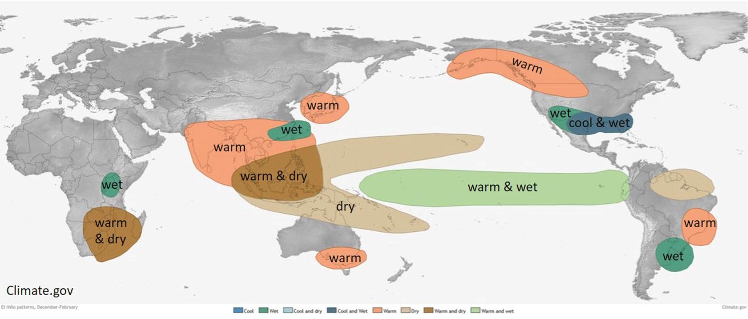
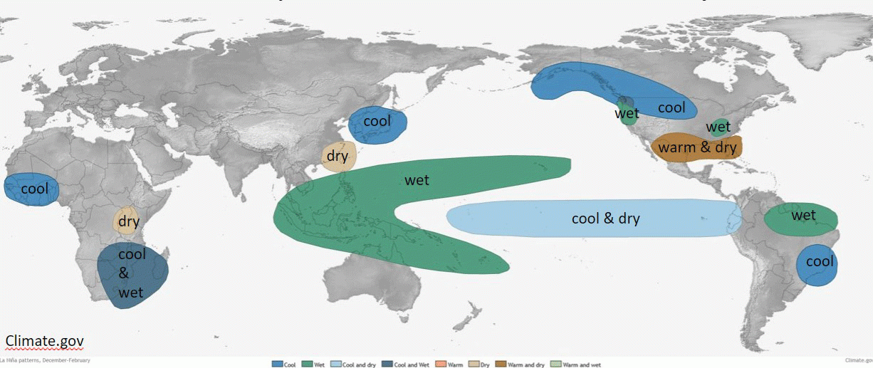
Finally, the El Niño Southern Oscillation (ENSO) is an ocean cycle characterized by years with either El Niño, neutral, or La Niña conditions. The shift between El Niño and La Niña influences the mid-latitude jet stream and hence weather. Perhaps more famous is El Niño, which refers to a warming of the eastern waters of the equatorial Pacific Ocean, mainly west of northern Latin America, leading to a rising air motion. This shift to El Niño is related to precipitation and snowpack in California during the winter, as well as precipitation patterns in other regions.
El Niño tends to create a subtropical, low-latitude jet stream that brings a lot of moisture to the southern United States and up the Mid-Atlantic region.
The interactions between the polar jet stream and the subtropical jet stream determine a large portion of the weather in the continental US. For instance, California tends to get a very wet winter in an El Niño year. 2015/16 was one of the strongest El Niño events since 1997/98, and was in part responsible for the freakish warmth of December 2015.
We can slow global warming
The good news is that we have the technology and practical solutions at hand to effectively address global warming. A crucial part of that effort is to significantly reduce the amount of heat-trapping emissions we are putting into the atmosphere. You can help.
Related resources
Understanding Future Groundwater Sustainability Scenarios

Earth Day Two Ways
Feet To The Fire