Like many major U.S. cities, Baltimore is culturally and socioeconomically diverse. The city encompasses low-income neighborhoods and national landmarks, such as the popular Inner Harbor—a key economic asset. It is also home to the Fell’s Point district, where some of the first U.S. naval ships were built and many eighteenth-century homes still stand.
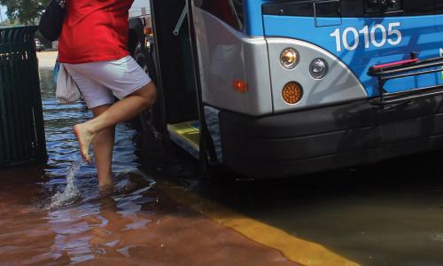
Baltimore’s coastal assets are prone to flooding during particularly high tides as well as storms. When combined with strong winds, high tides can limit pedestrian access to parts of the Inner Harbor, potentially affecting business revenues.
This profile is excerpted from the 2014 report, Encroaching Tides: How Sea Level Rise and Tidal Flooding Threaten U.S. East and Gulf Coast Communities over the next 30 Years."
Encroaching Tides
By 2045, Baltimore is projected to face more than a 10-fold increase in the number of tidal floods it sees each year—to more than 225—because of sea level rise alone (compared with today’s average). The city has already started work to protect its historic assets and prepare its economically vulnerable areas, such as Cherry Hill and Southeast Baltimore, where median family incomes are roughly one-third those in the Inner Harbor neighborhood. These measures include the creation of a Flood Resilience Area, which allows the city to apply flood-ready design standards within the 500-year floodplain.
Baltimore has also taken a forward-thinking approach to the hazard mitigation planning process. Instead of a routine update to its hazard mitigation plan, the city has integrated hazard mitigation and climate adaption into one comprehensive plan. The Disaster Preparedness and Planning Project (DP3) aims to create a risk-preparedness system, based on input from residents, that is storm-ready today and flexible enough to cope with future impacts of rising seas.
Related resources

Earth Day Two Ways

Feet To The Fire

The Science and Climate Litigation Webinar Series