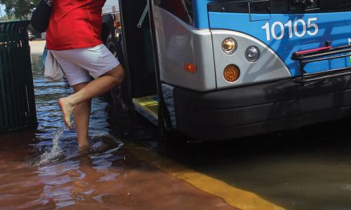
The low-lying city of Annapolis is well-acquainted with coastal flooding, as it faces regular disruptions to downtown streets and parking. A more than fourfold increase in tidal flooding since 1970 has made Annapolis among today’s most frequently flooded East Coast cities.
With a population of 40,000, this picturesque city lies on Chesapeake Bay, at the mouth of the Severn River, and is part of the Baltimore-Washington metropolitan area. This historic state capital was briefly the nation’s capital after the American Revolution. Many preindustrial colonial buildings still stand, harkening back to the days when the city was a hub for the transport of tobacco, iron, and grain.
Today the popular City Dock—a central meeting place along the waterfront—sees flooding around 50 times a year during high tides. During such flood events, seawater can move into downtown areas and surrounding neighborhoods, and push water out of storm drains and onto surrounding streets, even on fine sunny days with no wind or storms.
This profile is excerpted from the 2014 report, Encroaching Tides: How Sea Level Rise and Tidal Flooding Threaten U.S. East and Gulf Coast Communities over the next 30 Years.
During “spring tides”—the highest tides of the month, when the influence of the moon and sun is greatest—areas around the U.S. Naval Academy, the Market House, Compromise Street, and the Eastport neighborhood can become awash with seawater. In December 2012, for example, an extreme high tide combined with a southeasterly wind that prevented the bay from draining left residents knee-high in water. Streets were closed, as was the Eastport Bridge, and businesses on Dock Street were inundated. Parking lots were submerged and restaurant and store owners were forced to close their premises. Flip Walters, the city’s director of public works, said the flooding was more substantial than during Hurricane Sandy, and advised drivers against forcing their way through floodwaters and spraying their brakes with highly corrosive saltwater.
Encroaching Tides
Sea level at Annapolis has risen by more than a foot over the last century—more than twice the global average. Just since 1990, sea level has risen by three inches, and the number of minor floods has more than doubled. Flooding from high tides has become so common that residents of some neighborhoods feel anxious about flooding, even when the weather is fine.
Annapolis is also familiar with severe flooding associated with major storms. In 2006, for example, a five-foot storm surge from tropical storm Ernesto inundated downtown, affecting the ground floors of many buildings, including the Maritime Museum. And buildings at the U.S. Naval Academy flooded during Hurricane Isabel in 2003, incurring extensive damage.
In 2030, just 15 years from now, projections show that Annapolis may see another half-foot of sea level rise, and a tripling of flood events to around 180 a year. By 2045, projections of sea level rise of around a foot mean that Annapolis would face more than 360 flood events a year—about 50 of them extensive. If the city does not pursue substantial measures to defend against rising seas or retreat from the sea, parts of Annapolis would essentially never be dry again.
Taking action
To stem the damage wrought by a steadily encroaching waterfront, Annapolis is beginning to plan for a wetter future. Officials from the city and Anne Arundel County used funding from NOAA and the Maryland Coastal Zone Management Program to assess the area’s vulnerability to sea level rise. City officials are now using funding and expertise from the Federal Emergency Management Agency (FEMA), the Army Corps of Engineers, and the Maryland Historical Trust to study almost 200 structures at risk from rising seas. The result will be suggestions for how to mitigate future flooding, and an online database that allows first responders to survey potential damage immediately after a disaster.
Through a partnership with NOAA, the state also runs the CoastSmart Communities Program, which provides tools and resources, financial assistance, and training for local officials on coastal flooding. As part of a public education strategy, city officials are asking residents to take pictures of flooding from tidal inundation, storms, wind, and rain.
During ongoing public hearings on long-term development plans for downtown, officials also solicit suggestions for dealing with flooding. Suggestions have included an extension of the public boardwalk in City Dock, a contentious plan for a floodwall, and alterations to major infrastructure. The City Dock Master Plan and a recent flood mitigation report already take sea level rise into account.
The U.S. Naval Academy is also planning for sea level rise and climate change. Because the academy already faces disruption from road closings, restricted access to buildings, and flooding of sports fields, leaders realize that they will need more preparedness to continue operating. Toward that end, academy leaders are partnering with city officials and the state Department of Natural Resources to coordinate efforts to prepare for sea level rise. Both the Department of Defense and the Department of the Navy consider sea level rise a national security issue, and the academy participated in a study, with Annapolis as a pilot site, that modeled flooding that could occur when storm surge combines with higher seas.
According to Kevin Jenkins, director of the academy’s Facilities Management Division, “Each of us seemingly has a role and responsibility in sea level rise and climate change. Those roles and responsibilities are evolving rapidly. The immediate challenges are coordinating information and planning positive efforts on a local and regional level, while anticipating national and Department of Defense policies that will guide much-needed hazard mitigation actions.”
Related resources

Follow the Money

The Science and Climate Litigation Webinar Series
Understanding Future Groundwater Sustainability Scenarios