Savannah is a major port city that also boasts one of the nation’s most extensive National Historic Landmark Districts. The waterfront is in many ways the engine behind the city’s past and present prosperity. Founded as a major cotton export town, Savannah’s picturesque cobbled streets and old warehouses draw millions of visitors each year and provide a popular hub for recreational fishing. However, the city is entering a new era as riverfront buildings increasingly flood at high tide.
Neighboring Tybee Island, at the mouth of the Savannah River, was once known as Savannah’s beach. The island has a permanent population of around 3,000, which swells to 30,000 during the summer. Georgia’s most densely developed barrier island and a tourist destination, Tybee Island has a colorful past as the haunt of the notorious pirate Blackbeard.
Like Savannah, this vacation town knows that it sits on the front line of sea level rise and is already taking steps to adapt. These efforts include raising the elevation of electronic controls for city wells, placing tide gates on storm-sewer outflows, raising roads, and nourishing eroding beaches.
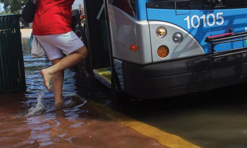
Floods in the Savannah area, including Tybee Island, now occur about 10 times a year—up from an average of just five or fewer some 40 years ago. The island is served by a single highway, Highway 80, which has become particularly prone to tidal flooding during a full or new moon. When water floods this and other roads, residents often contend with standing water, and downtown parking lots become inaccessible. Conditions are worse during higher spring tides, which occur twice a month when sun, moon, and Earth align. At these times, flooding can affect many sections of downtown, as well as stretches of the railway to the Port of Savannah.
Onshore winds and low-pressure systems off the coast often aggravate flooding by pushing water against the shore and allowing successive tides to build up. On those occasions, sewer pipes on parts of Tybee Island fill with seawater and cannot drain into the ocean, so backflow occurs. Such events leave cars stuck and properties flooded.
Projections show that by 2030, just 15 years from now, Savannah could see more than 30 tidal floods a year—a threefold increase compared with today. And sea level rise of almost half a foot will transform today’s nuisance tidal floods into more dangerous and damaging ones, with conditions that now occur only during the worst tidal floods.
Projections for 2045 are stark: Savannah could see a foot of sea level rise and a 10-fold increase in tidal flood events—to more than 100 annually. Each year, about 10 of those floods would fall into the extensive category, affecting highways, houses, businesses, infrastructure, and parks, across an expanded area of the city and region.
According to Jason Evans of the Carl Vinson Institute at the University of Georgia, “With a foot of sea level rise, you’d expect to see tidal flooding on the order of 100 days a year, rather than just four to five times a year as we do now.” Observes Paul Wolff, Tybee Island’s longest-sitting city council member, “Now is the time to plan and budget for infrastructure that we’ll need 20, 50, and 100 years from now to deal with the impacts of sea level rise.”
The cost of flood insurance for residents of Tybee Island is set to increase, partly because of the growing flood risk to their homes from sea level rise. FEMA plans to redraw flood maps in 2016, putting even more pressure on residents—more than a third of whom own vacation rentals that bring summer income.
Encroaching Tides
Taking action
Dealing with sea level rise is a steep challenge for historic coastal cities and low-lying barrier islands, but one that both Savannah and Tybee Island are trying to tackle. In southwest Tybee Island, which has seen chronic flooding, large-diameter pipes with tide gates—a multimillion-dollar project—now prevent seawater from flowing into the sewer system. These pipes can also store rainwater to limit flooding when heavy rains occur with high tides. Other neighborhoods have retrofitted storm sewers, and the island has built five canal pumping stations to deal with the highest tides.
More projects to increase resilience in the face of flooding are in the works. The Chatham County–Savannah Metropolitan Planning Commission has suggested that Savannah retrofit bridges with deeper foundations and increase the capacity of culverts to cope with both rainfall and seawater. In the longer term, the region plans to elevate new bridges and dig deeper foundations to enable infrastructure and buildings to withstand continued flooding. Other ideas include raising roads, building dunes, and even moving vulnerable facilities and infrastructure.
Building coastal resilience needs to be a national imperative, but many places will face limits both on their ability to adapt and on available funding. Stakeholders must eventually make difficult decisions about retreating from areas constantly inundated by tides. Meanwhile state and local planners need to fully account for sea level changes in store. Organizations in Georgia that are collaborating on solutions, such as the Carl Vinson Institute, Georgia Sea Grant, and the state’s Coastal Management Program, can provide leadership and vision for other such efforts nationwide.
Related resources
Understanding Future Groundwater Sustainability Scenarios

Earth Day Two Ways

Feet To The Fire